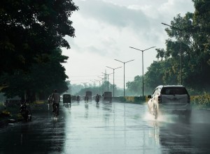
Roorkee: An artificial intelligence-based study conducted by researchers at the Indian Institute of Technology (IIT) Roorkee has indicated flood risks in nearly 85 percent districts of Uttarakhand and around 45 percent districts of Himachal Pradesh.
The research focused on mapping flood-prone regions in the Indian Himalayan belt using advanced AI technology. According to the study, several areas in the Himalayan region remain vulnerable to floods, landslides and avalanches.
Professor Mohit P. Mohanty from the Department of Water Resources Development and Management at IIT Roorkee said the increasing frequency of flash floods in the Himalayan region has created a need for faster and smarter solutions. He said traditional flood models often struggle in mountainous regions due to limited data, difficult terrain and sudden weather events.
He explained that the AI-based model can quickly generate detailed flood risk maps, making it more useful for early warning systems and disaster preparedness. The study was conducted keeping in view the rising number of extreme weather incidents in the Himalayan region.
Researchers stated that the high-risk zones identified by the model closely matched areas that witnessed flooding during recent monsoon seasons, including regions like Rudraprayag and major road corridors in Uttarakhand.
The study’s lead author is research scholar Rachit, while Vaibhav Tripathi is co-author. Professors Ashish Pandey and Anil Kumar Gupta were also part of the research team.
The study used a deep learning model known as CNN U-Net to analyse flood susceptibility at a 90-metre resolution. Researchers included 14 major factors in the model, including elevation, slope, vegetation cover and water flow characteristics, to identify highly vulnerable zones.
According to the findings, vegetation cover, topographic wetness index and elevation emerged among the most important factors linked to flood risk. Areas with low vegetation and higher chances of water accumulation were found to be particularly vulnerable.